Where They Lived
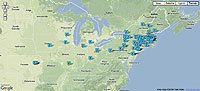
I have had it in mind for some time now to produce a Google map that displays the places of enlistment and/or birthplaces of the seventy-seven soldiers profiled in Union Faces. With the current book in the hands of the production team at Johns Hopkins University Press, I made time to complete the project. It is also linked from Faces of War.
The Google Maps API is easy to understand. Many of my questions were answered by trial and error and by viewing source code of similar maps. My friends at USA Today were also helpful. The most time-consuming part was producing the text and images for the profiles, plotting the latitude and longitude for each location, and building the xml file.
The payoff is seeing the locations of all the soldiers plotted on one map, and having the opportunity to look at them from a geographic perspective. To be able to view all the volunteers from Boston, or New York City, or Pennsylvania as a group is anew dynamic much different than the book's organization by the date of the soldier's central war story.
My next Google map project will be to track all the soldiers profiled as part of my column for Civil War News — about eighty-five men, North and South.
posted by Ron Coddington at 7:14 AM
![]()
![]()


0 Comments:
Post a Comment
<< Home